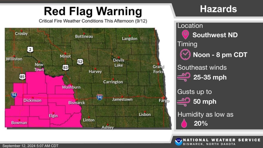
A number of counties in southwestern North Dakota are under a red flag warning today.
Jason Anglin is a meteorologist with the National Weather Service in Bismarck.
"Dunn, Mercer, Oliver, Billings, Stark, Morton, Slope, Hettinger, Grant, Bowman, Adams and Sioux Counties - so think of the Missouri River, it's west of the Missouri River, and into the southwestern part of the state."
Anglin says strong southern winds will enter that portion of the state this afternoon, and with warmer temperatures humidity values will be around 20 percent or so. He says this creates critical fire danger, and urges residents to be mindful…
"Just be mindful, like, any errant that could cause a fire - so think about, something as simple as hooking a trailer up and those chains can hit the ground - those can cause sparks. Pulling off into the grass with some hot brake pads, anything like that. Mowing your lawn and you hit a rock. Also, check with your local fire officials because sometimes, these red flag warnings do trigger burn bans."
The red flag warning will be in effect for the rest of today.
Anglin also says warmer temperatures into the 80s, which is above normal for this time of year, will persist over the next week or so.
He says the warm weather, along with strong winds contributes to fire danger in the state. But it also contributes to severe storms when cooler weather fronts enter the area – which he says will happen later today. Anglin says portions of western and central North Dakota are under a threat of some possible severe storms.
"So with the cold front coming through later this afternoon through tonight, there could be some stronger storms that initially develop either in Montana, or right near the Montana-North Dakota border. The front is kind of progressing eastward from there. Those portions of the state could see some large hail, some pretty strong damaging winds, and we cannot rule out a tornado threat, especially near that Montana-North Dakota border."
Anglin says normal temperatures for this time of the year are around the mid 70s. Some areas of the state could see temps in the low 90s over the next few days.

