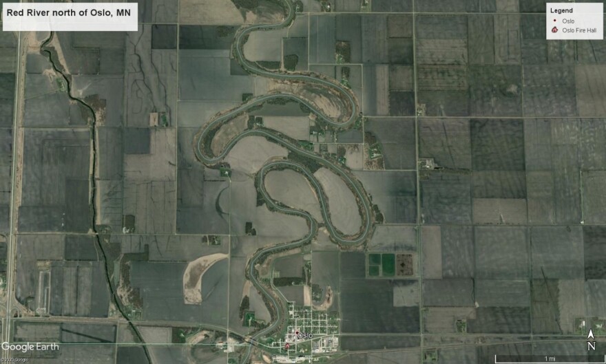
Look at an aerial photograph of most North Dakota rivers and you are likely to see it snake across the landscape in sinuous curves. These are low energy rivers or meandering rivers, as opposed to the higher energy or braided rivers. And if you look more closely, you are likely to see evidence of old channels and oxbows, evidence that these river channels have moved.
It might surprise the casual observer, but the water flowing down a stream is not all flowing at the same rate. Plus, the river channel itself is not symmetrical. It is typically deepest toward the outside of each bend. That is because the current is faster here, so it cuts more here. Conversely, the flow is slower on the inside of each bend and sediments tend to settle out, creating shallow areas. So over time, the river channel will move.
Most everyone has noticed a vertical bank or cliff on the outer side of a meander in a river. Also known as a “cut bank” this a place that receives considerable force of the flow. As a result, erosion flushes out the loose material and constantly erodes the cut-bank and may even cause the bank to occasionally slump or collapse into the river. That erosion causes the meander to erode and move further downstream. The eroded material is then carried downstream where it is deposited or settles out opposite a cut bank where the flow is much reduced, forming a point bar. These point bars, composed of accumulated sediment, may support willows and other vegetation.
If you follow one of these rivers, eventually you are likely to observe an oxbow. Oxbows, sometimes called “cutoff lakes” are generally crescent-shaped bodies of water associated with streams that form where two bends in the river converge, creating a “cut off.” Eventually both ends of the oxbow become blocked off by sediment, creating a closed basin. Periodic flooding may occur, and over time, sediment in the oxbow accumulates and may eventually become completely filled in.
-Chuck Lura
See aerial photographs of the Red, Sheyenne, Mouse, and Little Missouri rivers showing these features below:
Red River north of Oslo, MN. Flow is to the north. Note the meandering of the river here and potential for oxbows to form.

Sheyenne River in Cass County north of West Fargo. Flow is to the north. Note the oval shaped oxbow to the right of the present river channel.

Mouse River, on J. Clark Salyer National Wildlife Refuge, McHenry County. Flow is from southeast to northwest. Note abundance of oxbows.

Little Missouri River in Theodore Roosevelt National Park-North Unit, McKenzie County. Flow is to the north and east. Notice the linearity of vegetation near the river than follows earlier channels. How long until an oxbow forms here?


